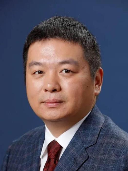
申抒含,男,研究員,中國科學院自動化研究所,模式識別國家重點實驗室
基本介紹
- 中文名:申抒含
- 職稱:研究員
- 工作單位:中國科學院自動化研究所
- 性別:男
研究領域,個人簡歷,發表論文,科研項目,
研究領域
三維計算機視覺,基於圖像的大規模場景三維重建,智慧型機器人三維環境感知,場景三維語義建模
個人簡歷
2019—,中國科學院自動化研究所,研究員
2013—2019,中國科學院自動化研究所,副研究員
2010—2013,中國科學院自動化研究所,助理研究員
2006—2010,上海交通大學,博士
2003—2006,西南交通大學,碩士
1999—2003,西南交通大學,學士
發表論文
(1)Depth-map Completion for Large Indoor Scene Reconstruction,Pattern Recognition,2019-11
(2)Complete Scene Reconstruction by Merging Images and Laser Scans,IEEE Transactions on Circuits and Systems for Video Technology,2019-10
(3)Efficient and Robust Large-Scale Structure-from-Motion via Track Selection and Camera Prioritization,ISPRS Journal of Photogrammetry and Remote Sensing,2019-10
(4)Scalable Point Cloud Meshing for Image Based Large Scale 3D Modeling,Visual Computing for Industry, Biomedicine, and Art,2019-10
(5)Visual Localization Using Sparse Semantic 3D Map,ICIP,2019-09
(6)Distributed Surface Reconstruction from Point Cloud for City-Scale Scenes,International Conference on 3D Vision,2019-09
(7)Multi-source Data Based 3D Digital Preservation of Large-scale Ancient Chinese Architecture: A Case Report,Virtual Reality & Intelligent Hardware,2019-05
(8)Detail Preserved Surface Reconstruction from Point Cloud,Sensors,2019
(9)Active Semantic Labeling of Street View Point Clouds,International Conference on Multimedia and Expo, ICME 2019,2019
(10)Ground and aerial meta-data integration for localization and reconstruction: A review,Pattern Recognition Letters,2019
(11)Accurate and Efficient Ground-to-Aerial Model Alignment,Pattern Recognition,2018
(12)Ancient Chinese Architecture 3D Preservation by Merging Ground and Aerial Point Clouds,ISPRS Journal of Photogrammetry and Remote Sensing,2018
(13)Fine-Level Semantic Labeling of Large-Scale 3D Model by Active Learning,International Conference on 3D Vision,2018
(14)Progressive Large-Scale Structure-from-Motion with Orthogonal MSTs,International Conference on 3D Vision,2018
(15)Large Scale Urban Scene Modeling from MVS Meshes,European Conference on Computer Vision,2018
(16)Geographic, Geometrical and Semantic Reconstruction of Urban Scene from High Resolution Oblique Aerial Images,IEEE/CAA Journal of Automatica Sinica,2017
(17)HSfM: Hybrid Structure-from-Motion,CVPR,2017
(18)Accurate Mesh-based Alignment for Ground and Aerial Multi-view Stereo Models,ICIP,2017
(19)CSfM: Community-based Structure from Motion,ICIP,2017
(20)Tracks Selection for Robust, Efficient and Scalable Large-Scale Structure from Motion,Pattern Recognition,2017
(21)High-Resolution Remote Sensing Data Classification over Urban Areas Using Random Forest Ensemble and Fully Connected Conditional Random Field,ISPRS International Journal of Geo-Information,2017
(22)Semantic labeling of High Resolution Aerial Images Using an Ensemble of Fully Convolutional Networks,Journal of Applied Remote Sensing,2017
(23)Variational Building Modeling from Urban MVS Meshes,International Conference on 3D Vision,2017
(24)Batched Incremental Structure-from-Motion,International Conference on 3D Vision,2017
(25)A New Visibility Model for Surface Reconstruction,CCCV,2017
(26)Dynamic Graph Cuts in Parallel,IEEE Transactions on Image Processing,2017
(27)Dynamic Parallel and Distributed Graph Cuts,IEEE Transactions on Image Processing,2016
(28)Global Fusion of Generalized Camera Model for Efficient Large-Scale Structure from Motion,Science China: Information Sciences,2016
(29)Automatic Building Extraction from Oblique Aerial Images,ICPR,2016
(30)Robust Global Translation Averaging with Feature Tracks,ICPR,2016
(31)Efficient Large-Scale Structure from Motion by Fusing Auxiliary Imaging Information,IEEE Transactions on Image Processing,2015
(32)How to Select Good Neighboring Images in Depth-Map Merging Based 3D Modeling,IEEE Transactions on Image Processing,2014
(33)Line Matching Across Views Based on Multiple View Stereo,Acta Automatica Sinica,2014
(34)Fusion of Auxiliary Imaging Information for Robust, Scalable and Fast 3D Reconstruction,ACCV,2014
(35)Accurate Multiple View 3D Reconstruction Using Patch Based Stereo for Large-Scale Scenes,IEEE Transactions on Image Processing,2013
(36)A Screw Axis Identification Method for Serial Robot Calibration Based on the POE Model,Industrial Robot: An International Journal,2012
(37)Depth-Map Merging for Multi-View Stereo with High Resolution Images,ICPR,2012
(38)A Fast Approach to Deformable Surface 3D Tracking,Pattern Recognition,2011
(39)Monocular 3D Tracking of Inextensible Deformable Surfaces under L2-Norm,IEEE Transactions on Image Processing,2010
(40)Convex Optimization for Non-Rigid Stereo Reconstruction,IEEE Transactions on Image Processing,2010
(41)Monocular 3D Tracking of Deformable Surfaces Using Sequential Second Order Cone Programming,Pattern Recognition,2010
(42)An Optimization Based Framework for Human Pose Estimation,IEEE Signal Processing Letters,2010
(43)Monocular Template-based Tracking of Inextensible Deformable Surfaces under L2-Norm,ACCV,2009
(44)Efficient Multiple Faces Tracking Based on Relevance Vector Machine and Boosting Learning,Journal of Visual Communication and Image Representation,2008
(45)Model Based Human Motion Tracking Using Probability Evolutionary Algorithm,Pattern Recognition Letters,2008,
(46)Deformable Surface Stereo Tracking-by-Detection Using Second Order Cone Programming,ICPR,2008
科研項目
( 1 )基於深度圖融合的大場景多視圖立體重建研究, 主持,國家級,2015-01--2018-12
( 2 )基於單目圖像的變形體三維重建, 主持,國家級,2012-01--2014-12
( 3 )中科院青促會, 主持,部委級,2015-01--2018-12
( 4 )基於n階引力場分類的構造方法, 參與,國家級,2013-01--2016-12
( 5 )城市場景稠密三維重建, 主持,院級,2014-01--2015-12
( 6 )多源圖像數據配準與融合, 參與,國家級,2013-01--2015-12
( 7 )三維場景中的高階能量最佳化理論, 參與,國家級,2014-01--2018-12
( 8 )場景三維信息獲取與理解, 參與,部委級,2012-01--2016-12
( 9 )手機圖像桌面場景三維重建, 主持,院級,2017-01--2017-12
( 10 )基於語義分析的大規模場景視覺重建關鍵技術研究, 參與,國家級,2017-01--2021-12
( 11 )中國古建三維數位化保護中的天地圖像融合問題研究, 主持,國家級,2019-01--2022-12
( 12 )基於視覺的大規模室內場景重建與定位, 主持,院級,2019-01--2019-12
( 13 )數字場景重建定製開發包模組授權使用協定, 主持,院級,2018-09--2019-06
